
Data Management Interface (DMI)
The following changes have been made to RiverWare DMI functionality.
Import Name Map from JSON file
The DMI Name Map functionality now supports importing slot mappings from a JSON format text file. Simulation object, account, and supply slots are supported. The name map can also export a template JSON file to show the format and to be used as a starting point for editing. This JSON format allows you to use database or other tools to generate the mapping and then import the mapping into the RiverWare DMI Name Map.
For more information, see Creating a Name Map from a JSON file in Data Management Interface (DMI).
Import/Export Dialog Box Accessibility
To allow easier import/export of database DMI components (DMI, Datasets, Name Maps), access to the import and export tools was added:
• The name map and dataset dialogs now have a menu item to export the current name map or dataset.
• The name map and dataset manager dialogs now have menu items to import.
For more information on import and export of database DMIs, see Sharing Database DMIs in Data Management Interface (DMI).
Removal of DSS Server
The DSS Dataset DMI connection was modified to remove the DSS Server and instead call the HEC-DSS library functions to read and write series and paired data. The new implementation is more robust and faster and doesn’t require installation of DSS Java runtime libraries. Further, a previous known-issue reading DSS 7 format files as described in DSS Dataset DMI Known Issue With DSS 7 was fixed with this change.
Web Service Datasets
This section describes modifications and enhancements to RiverWare’s Web Service datasets.
Changes to OpenSSL
See important changes to RiverWare’s use of the OpenSSL library in Changes to OpenSSL.
HDB Web Service
The “Klamath Basin Area Office” was added as a possible connection in the HDB Web Service Database DMI.
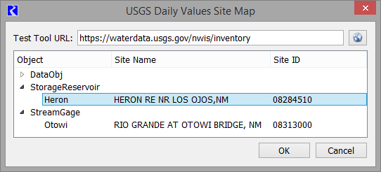
Web Service Site Map
The Web Service Dataset and DMI requires a mapping from RiverWare object and slot names to their web service identifiers. For the USGS web service, RiverWare objects and slots are mapped to their site and parameter IDs. The mappings can be made using the previous name map capability, but this is a tedious and error-prone process. To address this problem, a new type of name map, the Web Service Site Map, was introduced for the USGS web service.
This feature allows you to map objects to USGS site IDs by querying the web service for potential matches, which are then displayed in a menu. You then select the desired site and the tool will create the mapping relationship. Slots are mapped to their parameter IDs using the existing name map, but by employing the name map’s wildcard feature, it is expected that only a small number of mappings will be required
A sample site map is shown in the screenshot.
See USGS Site Maps in Data Management Interface (DMI) for more information.
Revised: 01/11/2023