
Local Inflow Spatial Disaggregation on Subbasin
The Local Inflow Spatial Disaggregation on Subbasin category allows the user to include the Control Point in a spatial disaggregation of local inflow. The methods in this category are executed from the subbasin containing this control point; see Local Inflow Spatial Disaggregation for details.
This method is the default for the Local Inflow Spatial Disaggregation on Subbasin category and should be selected when spatial disaggregation of local inflows is not desired.
There are no slots specific to this method.
This method holds the slots necessary for the calculation of Distributed Flow at an un-gaged control point using the known flow at the Gage Control Point. This method uses the procedure used in the Water Availability Models (WAM) developed by Dr. Ralph Wurbs at Texas A&M University. There are eight slots associated with this method: Local Inflow, Distributed Flow, Drainage Area, Curve Number, Mean Precipitation, Upstream Gages, Downstream Gage, and Excluded Gages. These slots are accessed by the computational subbasin when executing the computational subbasin’s WAM Precipitation Curve Number method. The computational subbasin uses the input Distributed Flow values in the Gage Control Point to calculate and set the Distributed Flow values at all other non-gage control points in the subbasin. See WAM Precipitation Curve Number for the computational subbasin’s WAM Precipitation Curve Number documentation.
Slots Specific to This Method
Local Inflow
Type: SeriesSlot
Units: FLOW
Description: The disaggregated local inflow to the control point
Information: If a disaggregation or forecast method is selected, the local inflow will be set to the result of the last stage of these methods.
I/O: Output
Links: Usually not linked
Distributed Flow
Type: SeriesSlot
Units: FLOW
Description: The cumulative inflow to the control point
Information: Accessed or set in the Spatial Disaggregation method on the computational subbasin. The default timestep size is 1 Month, but can be changed by the user. Timestep size is independent of model timestep size.
I/O: Input or computed. If input, the control point should be a Gage Control Point. Computed for all non-gage control points and set with an input flag.
Links: Usually not linked
Drainage Area
Type: ScalarSlot
Units: Area
Description: The total drainage area contributing to the control point
Information: Used in the Spatial Disaggregation method on the computational subbasin to calculate Distributed Flow
I/O: Required input
Links: Not linkable
Curve Number
Type: ScalarSlot
Units: No Units
Description: The NRCS curve number for the subbasin contributing to the control point
Information: Used in the Spatial Disaggregation method on the computational subbasin to calculate Distributed Flow. It must be between 0 and 100.
I/O: Required input
Links: Not linkable
Mean Precipitation
Type: ScalarSlot
Units: Length
Description: The monthly mean precipitation for the subbasin contributing to the control point. It must be greater than 0.
Information: Used in the Spatial Disaggregation method on the computational subbasin to calculate Distributed Flow.
I/O: Required input
Links: Usually not linked
Upstream Gages
Type: ListSlot
Units: NONE
Description: The list of upstream gages for this control point or gage
Information: Used in the Spatial Disaggregation method on the computation subbasin. The calculations require upstream gages to be entered for the downstream gage and for each Un-gaged Control Point.
I/O: Input
Links: Not linkable
Downstream Gage
Type: ListSlot
Units: NONE
Description: The downstream gage for this control point
Information: Used in the Spatial Disaggregation method on the computational subbasin. The calculations require that a downstream gage be entered for all Un-gaged Control Points.
I/O: Input
Links: Not linkable
Excluded Gages
Type: ListSlot
Units: NONE
Description: The list of gages excluded from the gain calculation for the downstream gage control point
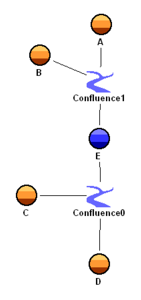
Information: Used in the Spatial Disaggregation method on the computational subbasin. This list is set on un-gaged control points using the WAM Curve Number method or the Drainage Area method. For most un-gaged control points, this list is empty. When the list is used, it specifies which gages should be lumped into the gain for its downstream gage control point. Include only gages that are tributary to the downstream gage but are not tributary to the un-gaged control point. For example, un-gaged control point E excludes gaged control point C in its calculation.

I/O: Input
Links: Not linkable
This method holds the slots necessary for the calculation of Distributed Flow at an Un-gaged Control Point using the known flow at the Gage Control Points. This method uses a ratio of un-gaged drainage area to gaged drainage area to scale gage flows. There are six slots associated with this method: Local Inflow, Distributed Flow, Drainage Area, Upstream Gages, Downstream Gage, and Excluded Gages. These slots are accessed by the computational subbasin when executing the computational subbasin’s Drainage Area method. The computational subbasin uses the input Distributed Flow values in the Gage Control Point(s) to calculate and set the Distributed Flow values at all other non-gage control points in the subbasin. See Drainage Area for the computational subbasin’s Drainage Area documentation.
Slots Specific to This Method
Local Inflow
Type: SeriesSlot
Units: FLOW
Description: The disaggregated local inflow to the control point
Information: If a disaggregation or forecast method is selected, the local inflow will be set to the result of the last stage of these methods.
I/O: Output
Links: Usually not linked
Distributed Flow
Type: SeriesSlot
Units: FLOW
Description: The cumulative inflow to the control point
Information: Accessed or set in the Spatial Disaggregation method on the computational subbasin. The default timestep size is 1 Month, but can be changed by the user. Timestep size is independent of model timestep size.
I/O: Input or computed. If input, the control point should be a Gage Control Point. Computed for all non-gage control points and set with an input flag.
Links: Usually not linked
Drainage Area
Type: ScalarSlot
Units: Area
Description: The total drainage area contributing to the control point
Information: Used in the Spatial Disaggregation method on the computational subbasin to calculate Distributed Flow
I/O: Required input
Links: Not linkable
Upstream Gages
Type: ListSlot
Units: NONE
Description: The list of upstream gages for this control point or gage
Information: Used in the Spatial Disaggregation method on the computation subbasin. The calculations require upstream gages to be entered for the downstream gage and for each Un-gaged Control Point.
I/O: Input
Links: Not linkable
Downstream Gage
Type: ListSlot
Units: NONE
Description: The downstream gage for this control point
Information: Used in the Spatial Disaggregation method on the computational subbasin. The calculations require that a downstream gage be entered for all Ungaged Control Points.
I/O: Input
Links: Not linkable
Excluded Gages
Type: ListSlot
Units: NONE
Description: The list of gages excluded from the gain calculation for the downstream gage control point
Information: Used in the Spatial Disaggregation method on the computational subbasin. This list is set on un-gaged control points using the WAM Curve Number method or the Drainage Area method. For most un-gaged control points, this list is empty. When the list is used, it specifies which gages should be lumped into the gain for its downstream gage control point. Include only gages that are tributary to the downstream gage but are not tributary to the un-gaged control point. For example, ungaged control point E excludes gaged control point C in its calculation.
I/O: Input
Links: Not linkable
Revised: 01/04/2021